T.19N. - R.6E. - Area Information > Adams County Townships | Online Discussion Forum
Big Flats Township WI
Big Flats Township is located in Adams County, Central Wisconsin at the main intersection of State Highway 13 & County Road C. Known for its ATV routes, Snowmobile trails, thousands of acres of public land , Big Roche-a-Cri Creek , Dead Horse Creek, Dry Creek, and Carter Creek. Big Flats also has 3 of the 23 named Rock Formations in Adams County; Rabbit Rock, Keystone Rock and Minnie Rock. There is a lot of land open to the Public via a large corporate Timber Company.
Big Flats Township meeting information, board members contact info plus Garbage & Recycling locations
- Big Flats Town Hall Address - 1104 County Road C Arkdale, WI. 54613
- Big Flats Township Zip Codes - 54613

Big Flats Township Wisconsin
Real Estate | Homes | Land | Condos | Multi-Family | Commercial Property
Photos & Pictures


Big Flats Wisconsin
Big Flats WI - Photo Gallery | Map
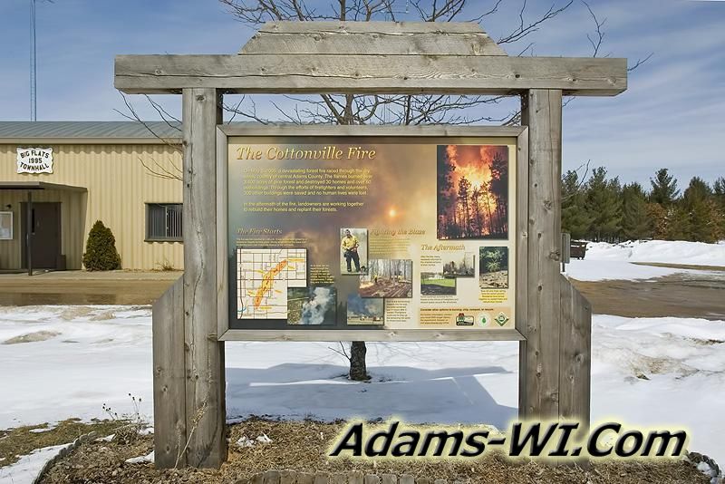
Big Flats, WI is located by the intersection of State Highway 13 & County Road C in Big Flats Township and it features the Big Flats Fire Station. This area has a mix of woods, and large farm fields with a combination of full time and vacation homes. Unfortunately it is also known for two tornados: a F3 on August 27th 1994 and a F1 on April 10th 2011 plus a major wildfire. On May 5th 2005 just south of Big Flats one of Wisconsin’s worst manmade fires started just east of Cottonville, WI about 1 mile away from Big Roche-A-Cri Lake. This fire spread rapidly, move on a north east path which burned over 6 miles long and about 1.5 miles wide at the widest point. You can find a billboard with information about the Cottonville Fire at the Big Flats Fire Station.
Cottonville Fire May 5th 2005 - https://thelandman.net/Wild_Fire.htm
Cottonville Tornado - https://adams-wi.com/april-10-2011-tornado.html
Big Flats Township
ABOUT: Big Flats Township is located in Adams County, Central Wisconsin at the main intersection of State Highway 13 & County Road C. Big Flats Township is known for its ATV routes, Snowmobile trails, thousands of acres of public land, Big Roche-a-Cri Creek, Dead Horse Creek, Dry Creek, and Carter Creek. Big Flats also has 3 of the 23 named Rock Formations in Adams County; Rabbit Rock, Keystone Rock and Minnie Rock. There is a lot of land open to the Public via a large corporate Timber Company which has been turned into farmland more and more in recent years.
Big Flats Town Hall
Cities, Towns and Villages
- Big Flats Wisconsin - Unincorporated
Lakes, Rivers, Creeks and Trout Streams
- Dead Horse Creek
- Big Roche-A-Cri Creek - Trout Stream
- Dry Creek
- Carter Creek - Trout Stream
Public Land & Area Features
- Rabbit Rock Wayside - Public
- Minnie Rock
- Keystone Rock
Developments and Subdivision in Adams County
- Big Buck Acres
- Big Flats Assessors Plat Number 1
- Bighorn Acres
- Brown Deer Acres Tracts
- Echo Valley Acres
- Ellas Acres
- Evergreen Acres (Dead Horse Creek)
- Fawn Ridge Subdivision
- Gold Crown Estates
- Green Acres
- Hidden Waters (Big Roche-A-Cri Creek)
- Hiland Acres
- Homestead Acres
- Nelsons Subdivision
- Nimrod Acres
- Pine Haven
- Pine View Subdivision
- Pleasant Acres
- Running Deer Acres
- The Back Forty
- The Green Acres
- Trout Valley (Big Roche-A-Cri Creek)
- Trout Valley East (Big Roche-A-Cri Creek)
- Trout Valley West (Big Roche-A-Cri Creek)
- Wildwood Acres
- Woodland Acres
Related Links
